From San Jose
The drive from the San Jose airport (Juan Santamaria International Airport) to Tamarindo will be about 5 hours and is fully paved with the new highway in place. We suggest exchanging at least $5 US dollars into Costa Rican colones for the tolls on the highway. Ask the rental car agent to send you off in the right direction, which should be west on Route 1, past the airport. Drive defensively and be aware when two lanes become one, “CEDA” means “Yield.
Note: The first 13 km uses the same “old” route to Manuel Antonio. GPS devices might not be updated and will likely still have the “old” route so do not rely on them to follow the complete recommended route.
- Once on Route 1 – follow signs to San Ramon, and continue straight ahead for about 10 km. After the second bridge crossing, get in the right lane and take the next exit (Route 3) for Jaco / Quepos / Manuel Antonio. There is also a sign here for Punta Leona and Atenas. Turn left at the stop sign, crossing back over Route 1.
- Follow Route 3 for about 3 km. Look for a large Christian church on the left and then a soccer field and make a left on the road immediately after it. You are on the road to Turrucares. There are no signs and it’s a secondary road, so don’t think you’ve made a mistake. It’s currently the best connection to the toll highway from the airport.
- Drive for another 3 km through this somewhat winding road. Once you arrive at the highway intersection turn left BEFORE the highway. Again, there are no signs here yet. Be careful as it’s a narrow two-way gravel access road. After some 300 meters you will arrive at a roundabout. Make a right following the highway signs to Orotina / Atenas.
- Stay on this highway and you will be passing a few toll booths so make sure you have some colones. You will pass signs for Jaco/Quepos and shortly after you will see the Pacific Ocean in front of you. Continue a couple more minutes with the ocean along the left of you and you will see an exit sign to the right for Puntarenas. Continue and you will pass the Puntarenas turn off on your right hand side. Continue on the Pan-American highway towards Liberia.
- Once you reach Liberia you will see a main intersection with a Shell gas station (on left), Burger King (on left), and McDonalds (on right) on all three corners of this traffic light. Here you make a left and this puts you on the road heading towards Liberia airport.
- You will be on Rt. 21 and will pass the airport on your right hand side. Continue South through Comunidad to Belén. The Road between the airport and Belén is well paved and passes through sugar cane farms and there are small towns along the way.You will also pass Do It Center and some other stores in a group. You’ll find abundant places to stop for a cold drink and snacks. Belén is a well marked and busy three way intersection. You’ll see a new commercial strip with gas station on the Southwest corner and a lot of signs indicating to turn right for Tamarindo, Potrero, Huacas, Brasilito and other towns. Turn Right and follow signs to Flamingo, Huacas and Tamarindo.
- In Huacas you turn left for Tamarindo and all you have to do is follow the road signs, which will lead you to a right turn in the small village of Villareal. Follow this road and you will have reached your destination: Playa Tamarindo.
From Liberia
Upon leaving the Daniel Oduber Quirós International Airport (LIR) you make a right and will be on Rt. 21. Continue South through Comunidad to Belén. The Road between the airport and Belén is well paved and passes through sugar cane farms and there are small towns along the way.You will also pass Do It Center and some other stores in a group. You’ll find abundant places to stop for a cold drink and snacks. Belén is a well marked and busy three way intersection. You’ll see a new commercial strip with gas station on the Southwest corner and a lot of signs indicating to turn right for Tamarindo, Potrero, Huacas, Brasilito and other towns. Turn Right and follow signs to Flamingo, Huacas and Tamarindo.
In Huacas you turn left for Tamarindo and all you have to do is follow the road signs, which will lead you to a right turn in the small village of Villareal. Follow this road and you will have reached your destination: Playa Tamarindo.
Map of Tamarindo
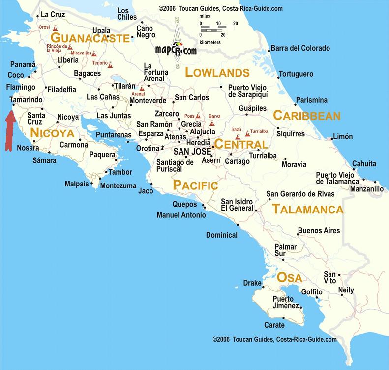
Map of Tamarindo
 +1 888-818-2097
 +506 8932-4731