Costa Rica National Parks

Home
Costa Rica National Parks

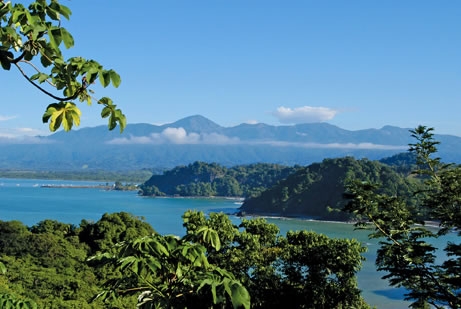
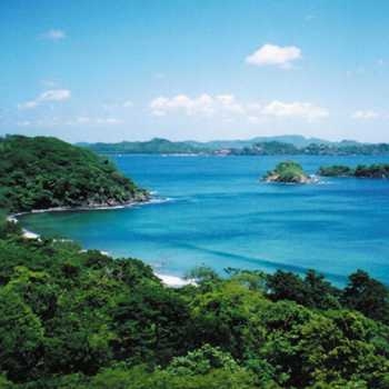
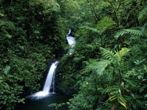
Costa Rica is well known for being one of the most bio-diverse countries in the world and the national parks of Costa Rica are certainly special. With fiery active volcanoes, long white sandy ribbons of pristine beaches, glistening waterfalls and lush tropical rainforest, Costa Rica is a paradise vacation destination for eco tourists..

Considered to be a “Living Eden,” well over one million tourists visit Costa Rica national parks every year. This beautiful country has an incredible twelve ecological zones, a blend of rainforest, cloud forest, protected marine areas and wetlands which are home to an abundance of the most fascinating flora and fauna in the world.

In order to protect this natural paradise, Costa Rica boasts one of the most developed and complex conservation systems in Latin America. Over 25% of the country’s land belongs to a conservation area. The Costa Rica national parks system has been hailed as one of the most innovative in the world and is used as a model for other countries to follow.

Costa Rica Frog
Costa Rica National Park in Manuel Antonio with Amazing rain forest

Costa Rica currently has 27 national parks, 58 wildlife refuges and 32 protected areas which are extremely popular ecotourism destinations. With over 10,000 flora species, 850 bird species, 205 mammal species, over 35,000 insect species and 220 species of reptiles, a visit to a Costa Rica national park promises to be an exciting eco adventure for all of the family.

A pioneer of ecotourism, well over half of the tourists that travel to Costa Rica visit one or more of its national parks. Many of Costa Rica’s national parks incorporate some of the most spectacular beaches of Costa Rica.

Volcano National Parks in Costa Rica

All of the stunning volcanoes in Costa Rica are located within the country’s national park system. Some of the best volcano national parks to visit in Costa Rica include:

  • Arenal Volcano National Park
  • Poas Volcano National Park
  • Rincon de la Vieja National Park
  • Irazu Volcano National Park
  • Tenorio Volcano National Park
  • Turrialba Volcano National Park

Popular Costa Rica National Parks

  • Manuel Antonio National Park
  • Corcovado National Park
  • Monteverde Cloud Forest Reserve
  • Tortuguero National Park
  • Marino Ballena National Park
scarlet macaw found around Arenal Volcano in Costa Rica
Manuel Antonio National Park Beach in Costa Rica
Toucan found throughout Manuel Antonio beach and National Park

Manuel Antonio National Park

  • Location: 7 kilometers south of Quepos, Puntarenas, Central Pacific, Costa Rica
  • Extension: 1700 acres of land mass and 135,906 acres of marine reserve
  • Hours of Operation: 7:30a.m. – 3:30p.m. Tuesday through Sunday; closed Mondays
  • Facilities: Administration and information offices are located within the grounds of the park. Picnic tables, restrooms, showers, drinking water and a pay phone located within the park.

Flora and Fauna at Manuel Antonio National Park

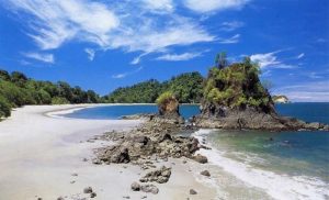
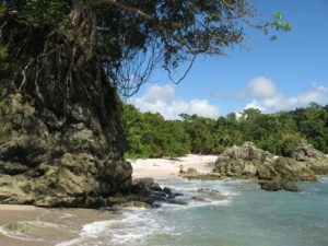
Manuel Antonio National Park is home to an abundance of exotic flora including the guácimo colorado, the pilón, the cedro maría, the guapinol, the cenizaro and the ceiba. The coastal flora that can be found near Playa Manuel Antonio beach includes manzanillo trees, almond trees, roble trees and coco trees.

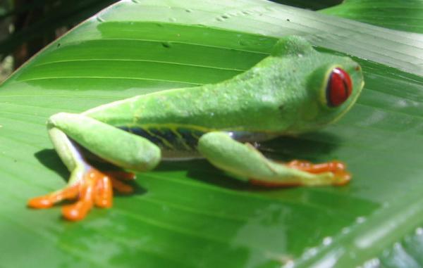
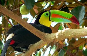
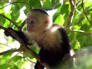
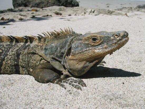
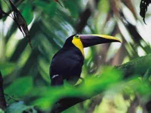
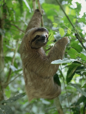
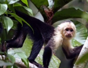
Species of Costa Rican wildlife found in Manuel Antonio National Park include three and two-toed sloths, howler monkeys, squirrel monkeys and capuchin monkeys, green iguanas and the white-nosed Coati. Bird species inhabiting Manuel Antonio National Park include toucans, parakeets, woodpeckers, pelicans, kingfishers and hawks. Resident dolphins and migrating whales can be spotted off of the coast of Manuel Antonio National Park. The shores are also occasional nesting grounds for Olive Ridley turtles and Pacific Green turtles.

Manuel Antonio National Park Facts

  • Manuel Antonio is an award winning top beach vacation destination, recognized by the Travelers Choice awards in 2010
  • Manuel Antonio National Park is the smallest in Costa Rica but receives the most visitors per year. Manuel Antonio National Park registered a controlled entry of 300,000 visitors for 2010. Despite its popularity, this Costa Rica national park continues to retain its natural beauty
  • Home to four of the Costa Rica’s most pristine white sand beaches, Manuel Antonio is a paradise eco tourism destination. Manuel Antonio is one of the few places in the world where you can enjoy an authentic tropical beach vacation
  • Manuel Antonio National Park has four beaches: Playa Manuel Antonio, Playa Espadilla Sur, Playa Teldoro, and Playita
Manuel Antonio National Park in the Central Pacific Costa Rica
Wildlife bird watching tours offered in Manuel Antonio National Park

Manuel Antonio National Park Tours and Activities

There are several exciting eco adventure tours available in the immediate area surrounding the Manuel Antonio National Park.

  • If you enjoy sport fishing, book a chartered sportfishing tour just off the coast of Manuel Antonio National Park
  • Take a snorkeling tour and explore the coral reef off of the coast of the Manuel Antonio National Park
  • Take a wildlife and bird watching tour through the rainforest of Manuel Antonio National Park in search of exotic wildlife with a local tour guide who will point out the different species of wildlife, flora and fauna
  • Take a stroll along the beautiful crescent shaped Playa Manuel Antonio, enjoy a refreshing swim and sit under the shade of the tropical greenery that lines this beautiful beach in Costa Rica
  • If you enjoy hiking, Manuel Antonio National Park has five short trails that guide you through the park. The trails offer the most stunning coastal views, all of which are well maintained and have good signage
  • Take the 1.3 mile main trail which passes by the national parks beaches. The Punta Catedral trail goes off the main trail and leads to Cathedral Point, offering several gorgeous views of the Central Pacific coast. The Playa Gemelas and Punto Escondido trail leads to two secluded Manuel Antonio beaches. Of all the hiking routes, the Mirador trail is the most challenging

Directions to Manuel Antonio National Park

  • From San Jose, take the Caldera Highway Route 27 West for about an hour. Drive on the highway through 4 toll booths. Take the exit to Route 34, follow signs for Jaco / Quepos. This exit forms a loop and then you bypass a roundabout to continue straight to Jaco for approximately 36 km.
  • Follow Route 34 Costanera Highway for about 30 minutes to cross over the Tarcoles River Bridge; a popular viewing point to witness crocodiles lurking in and around the river.
  • Shortly thereafter the ocean will appear on your right hand side. Pass Punta Leona and Herradura; an Automercado supermarket will be on the right hand side of the road.
  • Follow signs for Jaco and Manuel Antonio. Pass through a roundabout; the road then leads directly to Quepos. Once in Quepos, the road becomes one lane. Drive past shops/restaurants and turn left just after the small park. Follow signs for Manuel Antonio. This road leads out of Quepos and directly Manuel Antonio National Park. The park will be on the left hand side across from the beach.
Capuchin monkey one of three species found in Costa Rica National Parks
Corcovado National Park in the Osa Peninsula
Tapir along Corcovado National Park in Costa Rica

Corcovado National Park

  • Location: Osa Pensinsula, South Pacific
  • Extension: 104,900 acres
  • Hours of Operation: 6 a.m. to 4 p.m. Overnight stays available at specific ranger stations but must be pre-booked. Each ranger station has specific opening times; see below for more info regarding the different ranger stations.
  • Facilities: Park facilities vary according to the access point and differing ranger stations. All ranger stations are connected through hiking trails and offer camp sites, drinking water and communication facilities. Bunkhouses and meals can be booked in advance.

Flora and Fauna at Corcovado National Park

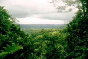
The brilliant flora found at Corcovado National Park is notable for its variety, making it one of the most biologically diverse national parks not only in Costa Rica, but in the entire world. Corcovado National Park is considered to be the jewel in the crown of the Costa Rica’s national park system.

There are over 13 identified vegetation types within the extension of Corcovado National Park including montane forests, cloud forests filled with oak trees and ferns and the jolillo forest with beautiful palms, prairie forest and swamp forest. The incredible flora of Corcovado National Park’s dense rainforest includes over 500 species of trees including the Purple Heart, the banak and the crab wood tree that account for over ¼ of all tree species found in Costa Rica.

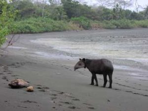
The plentiful rainforest landscape at Corcovado National Park is home to some of Costa Rica’s most fascinating wildlife including the endangered tapir, the rare harpy eagle, the American crocodile, the spider monkey, the two-toed and the three-toed sloth and the rarely seen feline species of puma, jaguar and ocelots. Poison arrow dart frogs, snakes and anteaters are also found within Corcovado National Park.

Corcovado National Park Facts

  • Corcovado National Park forms part of the Osa Conservation Area, which includes the Golfo Dulce Reserve, the Guaymi Indian Reservation, and the preserves of Isla del Cano, Piedras Blancas and the Terraba wetlands
  • Corcovado National Park is the focus of year round biological investigations
  • In comparison to other Costa Rica national parks, Corcovado is considered to have the most challenging landscape, proving popular with avid hikers
  • Corcovado National Park is home to a virtually untouched white sand beach extending for 20 km
  • The ecological biodiversity in Corcovado National Park is unique; National Geographic has called it “the most biologically intense place on Earth”
  • Corcovado National Park has a total of six ranger stations including, Los Patos, Sirena, San Pedrillo, and La Llorona

Corcovado National Park Tours and Activities

  • Corcovado National Park offers some of the best and most challenging hiking trails. The 2 kilometer, 1 hour Catarata trail leads through the rainforest arriving at a beautiful waterfall.
  • The Pargo hiking trail runs along the riverbanks in the Corcovado National Park and is 3 kilometers long.
  • Las Marias trail is especially recommended for birdwatchers and leads to the La Llorona waterfall. It takes about 4-5 hours to walk the 10 kilometer trail.
  • For extreme hikers, take Sirena San Pedrillo trail which is 25 km long. Open from December to April, the hike takes 8-10 hours to complete; make sure to take plenty of water and food
  • Guided tours through the Corcovado National Park available for bird watching and wildlife enthusiasts
Wild life in Corcovado National Park
Iguana found throughout Costa Rica and it's national parks

San Pedrillo Ranger Station at Corcovado National Park

  • San Pedrillo Ranger Station is located on the northwestern border of Corcovado National Park and 17 kilometers south west of the town of Agujitas
  • Easily accessible on foot or horseback
  • Only open during the green season, Costa Rican summer, closing during the month of April and opening again in November
  • Facilities include drinking water, camp site for up to 30 tents, 4 toilets and 5 showers
  • A number of trails lead off from the San Pedrillo Ranger Station and guided bird watching tours and wildlife tours are available

Los Patos Ranger Station at Corcovado National Park

  • Los Patos Ranger Station is located on the eastern side of Corcovado National Park
  • Easily accessible by foot or part of the way on horseback via three different entrances
  • The main access is via the Rincon River valley, a forty five minutes hike from the park boundary to Los Patos Ranger Station. Horses are not permitted within the park
  • Los Patos can also be accessed via the Sirena Ranger Station. This is a 21 kilometer trail that connects the two ranger stations located within Corcovado National Park
  • The third trail leads from the Guaymi Indian Reservation
  • Los Patos is open all year and has camping facilities for up to twenty people, four toilets, showers and drinking water but no meals.

Sirena Ranger Station at Corcovado National Park

  • The Sirena Ranger Station is the main station of the Corcovado National Park
  • Center for academic research into biodiversity of the park
  • Camping, overnight dorm lodging and hot meals available
  • Solar powered electricity only used to power the ranger station. Solar powered cell phone communication available to only to park rangers
  • Accessed by plane and boat
  • The Sirena Ranger station is linked to all other stations in Corcovado National Park
  • Several wildlife and hiking trails lead off from the Sirena Ranger Station

La Leona Ranger Station at Corcovado National Park

  • La Leona Ranger Station is located on the Pacific coast, to the south of the Corcovado National Park
  • A trail along the beach links La Leona with La Sirena ranger station
  • Open all year; offers camping facilities for up to 15 people
  • Drinking water available
  • Three toilets, 3 showers and a communal cooking area available
  • No mapped out trails lead from La Leona Ranger Station

Directions to Corcovado National Park

  • From San Jose, take the Pan American Highway East. The road curves South and changes designation from Highway 1 to Highway 2, although it’s still the Pan American Highway.
  • Drive 30 miles past Cartago until reaching reach San Isidro el General. Total drive time at this point is approximately 3 1/2 hours; 92 miles.
  • Continue south on the Pan American Highway to Piedras Blancas. Turn right (West) on 245 for Puerto Jimenez and Corcovado National Park. From San Jose, the total distance is about 240 miles; approximately 9 hours.
Waterfall in Monteverde cloud forest reserve
Monteverde reserve located in Costa Rica
Monteverde cloud forest toucan

Monteverde Cloud Forest Reserve

  • Location: Puntarenas, Costa Rica, situated on the Continental divide in Northwestern Costa Rica and extending down the Caribbean and Pacific slopes.
  • Extension: Approximately 25,000 acres
  • Hours of Operation: 7.00 a.m. to 4 p.m. daily
  • Facilities: Three shelters available, each housing ten people. Each shelter has bunk beds, a gas stove, cooking utensils and drinking water. Reservations required. Information center, butterfly gardens, small cafeteria and restaurant, restrooms and gift shop located within the park.

Flora and Fauna at Monteverde Cloud Forest Reserve

The Monteverde Cloud Forest Reserve has one of the most unique climates in the world, supporting four bioclimatic communities. This humid forest is home to an abundance of flora species, principally moss, bromeliads and more than five hundred varieties of orchid. At last count, over 3000 species of plants have been identified in this cloud forest reserve.

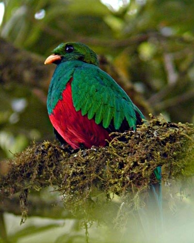
Monteverde Cloud Forest Reserve is home to some of the most interesting species of Costa Rica wildlife including over 100 species of mammals, more than 400 species of birds and 120 species of amphibians and reptiles. Jaguars, tapirs, sloths, golden toads, quetzals, porcupines, deer and over thirty species of humming birds can be found in this dense and magnificent cloud forest.

Monteverde Cloud Forest Reserve Facts

  • At approximately 1400 meters above sea level, Monteverde is cold, with an average yearly temperature of 18 degrees Celsius / 64.4 degrees Fahrenheit
  • The high altitude of Monteverde Cloud Forest ensures a steady supply of clouds that contain moisture which is distributed from the highest point of the rainforest to the ecosystems below
  • Monteverde Cloud Forest Reserve was voted one of the “7 Wonders of Costa Rica” in the top selling national newspaper La Nacion
  • The Monteverde Cloud Forest was listed in the top 100 places to see in the world before it disappears
  • Monteverde receives more than 250,000 tourists a year; 70,000 of these tourists visit the Cloud Forest Reserve
  • Monteverde Cloud Forest Reserve is home to the largest number of orchids in the world, with 34 of its 500 species newly discovered
  • The Monteverde area is the settlement location of a group of Quakers who arrived in the early 1950’s. Aside from dairy and cheese production, some of the Quaker families that settled also helped establish the Monteverde Cloud Forest Reserve
Monteverde cloud forest in Puntarenas Costa Rica
3 Toed Sloth found throughout Costa Rica and it's National Parks

Monteverde Cloud Forest Reserve Tours and Activities

  • Bilingual guided tours are available in English and Spanish; the entrance fee to the Monteverde Cloud Forest Reserve includes this 2.5 hour guided tour
  • If you enjoy wildlife then there is a bird watching tour that takes you through the many elevations of the Monteverde Cloud Forest Reserve.
  • If you enjoy hiking tours then you’ll enjoy a trek through the Monteverde Cloud Forest hiking trails. There are a total of eight well marked trails, each varying in distance and difficulty, making it one of the best places in Costa Rica for an eco adventure tour
  • The Sendero Bosque Nuboso trail offers spectacular views and an abundance of flora and fauna. This trail is 1.9 kilometers long, takes 1.5 hours to complete and can be hiked without a tour guide
  • El Camino trail is 2 kilometers long, takes 1.5 hours to complete and is a wider trail with more natural light. El Camino trail is particularly recommended for birdwatchers and butterfly lovers
  • The Sendero Pantanoso trail is 1.6 kilometers long and takes about 1.25 hours to complete. The Sendero Pantanoso trail passes by the reserve’s swamp landscape featuring an abundance of fascinating flora and fauna
  • The Sendero El Rio trail is 1.9 kilometers long and takes around 1.5 hours to complete. This beautiful trail takes you along the Cloud Forest Reserves river banks including the Quebrada Cuecha and a picturesque waterfall
  • The Sendero Chomogo trail is 1.8 kilometers long and takes around 1.25 hours. The tallest of all the trails, this hike will take you 5,510 ft above sea level
  • The George Powell trail is a short 0.2 kilometer trail taking only ten minutes to complete and leads you through secondary rainforest
  • The Sendero Brillante trail is 0.3 kilometers long, taking ten minutes, passing through the Continental Divide and offering spectacular aerial views
  • The Sendero Roble trail is 0.4 kilometers long and this narrow trail leads to a cluster of heliconia trees
  • Take a walk along the Monteverde Cloud Forest suspended bridge, 100 meters high and with panoramic views of one of the most beautiful landscapes of Costa Rica
  • Known as one of the best canopy tours in Costa Rica, the Sky Trek whizzes through the Monteverde Cloud Forest. With a 130 meter tall observation tower, 9 interconnected canopy cables, the longest at 770 meters long, this is canopy tour is highly recommended
  • Guided nocturnal tours are available and last from one to two and a half hours

Directions to Monteverde Cloud Forest Reserve

From San Jose: Take the Pan-American Highway North. Drive through Alajuela towards the town of San Ramon and continue North through Miramar. There are signs for Monteverde, Sky Trek and Selvatura near Caballo Blanco Restaurant. Look for a sign with a large white horse on the right hand side. Follow these signs towards a turnoff just beyond a gas station. This road turns from a paved road into a dirt road after a few kilometers. Continue to drive down this bumpy, winding road and follow the signs to Monteverde. You will eventually pass a cemetery; continue driving for another 30 minutes. When the road becomes paved again you are now driving into Santa Elena. Total drive time is approximately 4 hours.

From Liberia: Take the Pan-American Highway South headed towards San Jose. Continue through the towns of Bagaces and then Cañas. Continue for about another 25 minutes. Turn left when you see the entrance to to “Las Juntas.”Continue driving for another hour and a half until arriving in Monteverde.

Alternatively, you can continue further south to the entrance of Sardinal and turn left here instead of taking the La Juntas turnoff. This way takes a little longer, but the road conditions are much better. Total drive time for both routes is approximately 3 hours.

Manuel Antonio National Park with gorgeous beaches
Costa Rica National Parks offer amazing jungle and exotic wildlife
Corcovado National Park and it's beach

Tortuguero National Park

  • Location: Situated on the Caribbean coast, 87 kilometers northwest of Limon and 267 kilometers from San Jose
  • Extension: 47 acres of land mass plus 129,000 acres of marine reserve
  • Tortuguero National Park Hours of Operation: 8:00 am – 6:00 pm, and at night with authorized guides and groups.

Tortuguero National Park Flora and Fauna

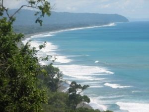
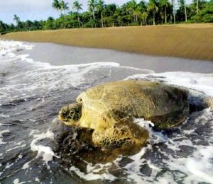
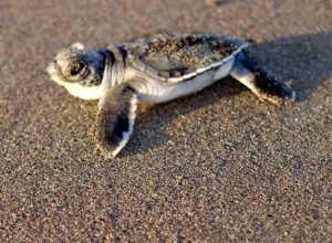
Tortuguero National Park is best known as the nesting site for six of the eight sea turtle species found in Costa Rica including the Leatherback Turtle, Olive Ridley Turtle, Loggerhead Turtle and Hawksbill Turtle. Consequently, the Tortuguero National Park is considered to be one of the best places for eco tourism and turtle watching tours along the Caribbean Coast in Limon. Its extensive coastline is where sea turtles arrive during nesting season to lay their eggs.

Tortuguero National Park is a blend of tropical lowland wet forest, beach, mangroves and swamp. Common flora that can be found in Tortuguero National Park include Passion Fruit trees, Ceiba, Crabwood and Banak as well as Heliconias, Aquatic Lillies and wild Plantain.

With an abundance of Costa Rica wildlife, Tortuguero Park is the perfect habitat for river turtles, crocodiles, otters, howler monkeys, capuchin monkeys, green macaws, kingfishers and toucans amongst 300 other identified species of tropical birds. Notoriously difficult to spot in Costa Rica, rarer species including jaguars, tapirs, ocelots, cougars and manatees can also be found in Tortuguero National Park.

Tortuguero National Park Facts

  • “Tortuguero” means area of turtles or grouping of turtles in Spanish.
  • Tortuguero National Park extends north 22 kilometers along the Caribbean coast of Costa Rica, beginning at Jaloba and reaching up to the Tortuguero village.
  • Recognized as one of the wettest areas in the country, nearly 20ft of rain falls in the Tortuguero village every year. December, June and July are the wettest months with February, March and September being the driest.
  • As of 1963, Tortuguero became a protected sea turtle nesting sanctuary. A collaborative effort between the Caribbean Conservation Corporation and sea turtle biologist Archie Carr helped Tortuguero become an officially declared a national park in 1970.
  • It is estimated that an incredible 30,000 sea turtles arrive at this Costa Rican national park every year. Tortuguero National Park protects one of the most important nesting grounds in the world for green sea turtles. They arrive every year from June to October with the most significant numbers arriving in September. Giant Leatherback sea turtles arrive between mid-February to July. The Hawksbill sea turtle also arrives during the month of July to nest.
  • Barra del Colorado Wildlife Refuge is located to the north of the Tortuguero National Park.
  • The Parismina River and the Cariari National Wetlands are located to the south of Tortuguero National Park.
  • The Dr. Archie Carr Wildlife Refuge operates a biological station at the mouth of the Tortuguero River where they carry out tagging and extensive research on sea turtles in Costa Rica.
Tortuguero National Park aerial picture
Famous leather back turtle in Tortuguero National Park
Tortuguero National Park kayak tour through the canals

Tortuguero National Park Tours and Activities

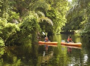
There are several exciting eco adventure tours that you can take while visiting the Tortuguero National Park.

  • Without a doubt sea turtle nesting tours are the most popular eco tourism activity at Tortuguero National Park.
  • If you enjoy hiking, there is a marked trail along the beach for sea turtle watching during the day, but most of the activity occurs at during the evening hours. The 2 km Gavilan Trail meanders between the rain forest and beach. The 2km-long El Gavilán Trail leads south from the Cuatro Esquinas ranger station south of Tortuguero village and takes in both beach and rain forest.
  • Take a hiking eco tour up to Cerro Tortuguero, you will have spectacular views of Costa Rica wildlife and of the Caribbean coast.
  • You can hire a local tour guide who can take you to the sea turtle nesting area at night; no one is permitted to enter the 22 kilometer protected stretch after 6 p.m. without a tour guide. Only 400 people are allowed on the beach per night and you are requested to follow strict guidelines which include not taking your camera or flashlight and remaining silent. You can coordinate this nocturnal sea turtle nesting tour at the Tortuguero Village.
  • Tortuguero National Park is mostly made up of coastal rain forest and there are an endless amount of canals. The best way to experience the wonders of this national park is by boat, canoe or kayak which can be rented in the Tortuguero village or through the Save Manatee Foundation.
  • If you want to stand a good chance of seeing the abundance of wildlife in Tortuguero National Park, it’s best to hire a local tour guide. Take wildlife and bird watching tours by boat through the rain forest in search of exotic wildlife. The local tour guide will be able to point out all of the different species of Costa Rica flora and fauna.

Tortuguero National Park Facilities

  • Although camping is not allowed in Tortuguero National park, camp sites can be found at the administration headquarters and the Ranger to the south of the village.
  • The Cuatro Esquinas Administration Headquarters offers camping and there are three trails that lead from this station. El Gavilan Trail takes you to the beach and the Ceiba and Bomba trail take you to Tortuguero Hill where you can get a spectacular view of the area.
  • The Sector Jalova Ranger Station is located to the south of Tortuguero National Park and is near the Jalova Lagoon. The Tragon and La Ranita Roja trails are good for short nature hikes through the rainforest.
  • The Aguas Frias RangerStation is located to the west of the Tortuguero National Park. Los Raudales Nature Trail takes you to a scenic look-out point.
  • The Tortuguero National Park Ranger Stations have washrooms and drinking water.

Driving Directions to Tortugero National Park

From San Jose Costa Rica, take the Guapiles Highway toward the city of Limon. At the Bay of Moin, near Limon, is the start of a navigable canal which heads north through the Cariari National Wetlands and into the wilderness area of Tortuguero National Park. Boats are available in Moin, pre-arrange early morning departures.

Tortuguero National Park baby turtle
Exotic frog found around Tortuguero in Costa Rica
Capuccin monkey also known as the white faced monkey

Marino Ballena National Park

  • Location: Situated 185 kilometers southwest of the capital, San Jose, located on the Pacific coast of Costa Rica and 16 kilometers south of Dominical.
  • Extension: Marino Ballena National Park has 270 acres of beach and coastal land and 13,300 acres of marine reserve.
  • Hours of Operation: Open seven days a week from 8 a.m. to 4 p.m.

Flora and Fauna

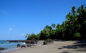
Home to the largest coral reef in the Pacific Coast, Costa Rica’s Marino Ballena National Park has over eighteen species of coral and is defined by long stretches of white sandy beach rich in tea and red mangroves and wild anona, manzanillo and palm trees.

The Marino Ballena National Park is abundant with the most fascinating wildlife, inhabited by green marine iguanas, pelicans, woodpeckers, frigate birds, herons and marine species including resident bottle nosed dolphins, parrot and angel fish, lobsters, butterfly fish, barracudas and cat and white tipped reef sharks.

One of the largest, most fascinating mammals in the world, the migrating humpback whales visits the warm tropical waters of the Marino Ballena National Park between December and March and July to October every year.

Olive Ridley and Hawksbill seaturtles come ashore between July and November to dig out their sand nests and lay their eggs. Each turtle can lay an average of 65 to 105 eggs.

Marino Ballena National Park facts

  • The Marino Ballena National Park was created on the 6th of February 1989. Its borders were later expanded in 1992 to incorporate a greater expanse of marine reserve.
  • Marino Ballena National Park is named after the Humpback Whales that migrate to Costa Rica each year from December to April to mate.
  • Marino Ballena National Park is perhaps best known for the incredible natural sandbank formation that looks exactly like a whale’s tail, otherwise known as the Punta Uvita Tombolo.
  • Uvita, Ballena, Arco and Pinuelas are the often deserted beaches that form part of Marino Ballena National Park. The rest of this protected coast is made up of rocky cliffs and shores.
  • Marino Ballena National Park also incorporates three Costa Rican islands, known as the three sisters, which form part of the coral reef.
  • The northern border of the Marino Ballena national park begins at the Rio Morete and extends 15 kilometers south to Punta Pinuela.
  • Rainy season runs from May to November and the dry season runs from December to April in this South Pacific region of Costa Rica.

Marino Ballena National Park Tours and Activities

Marino Ballena National Park offers several exciting Costa Rican adventure tours for all the family.

  • Take an amazing whale and dolphin watching boat tour. Lasting from two to three hours, you can also snorkel on this Costa Rican eco adventure tour. For a minimum of two people, the whale watching tour runs from November to March and July to September. You’ll be able to spot humpback and pilot whales, as well as resident bottle nosed dolphins.
  • At low tide, snorkeling is an excellent water activity to enjoy along the Marino Ballena shoreline. Take a snorkeling tour at Marino Ballena National Park and observe an abundance of marine life that inhabits the largest coral reef on the pacific coast. This two hour tour will take you out to Isla Ballena and through the Ventanas caves. Transport is available from vacation accommodations located within proximity to the beachside Costa Rica communities of Dominical, Uvita, and Ojochal. Tour rates include a bilingual guide, park entrance fees, fresh fruit and water, as well as snorkeling equipment.
  • Visit the amazing Whale Tail at low tide, when a 1 km sand path opens up. Otherwise known as the Tombolo de Punta Uvita this naturally formed Whales Tail is made up of natural sand deposits. This is a must if you are visiting the Marino Ballena National Park.
  • Take a guided one day boat tour and visit the famous Whale Tail, Ballena Island, Tres Hermanas and Ventanas Sea caves. Your boat will be followed by dolphins, and if you’re lucky, you may even see a Costa Rican seaturtle. This tour includes park entrance fees, fresh fruit snacks, water and snorkeling equipment as well as vacation accommodation pick-up from the beachside communities of Uvita, Dominical and Ojochal.
  • If you want to be the captain of your own sea vessel, then take a half day kayaking tour, setting off from Playa Pinuelas. A bilingual guide will give you a safety induction and ensure your wearing your life vest as you set off on the first 1 ½ hour leg of your kayaking adventure. When you reach Ballena Island, you will enjoy a light lunch of fresh fruit and cold drinks and then you can explore underwater, snorkeling around the island. After an action packed few hours, enjoy a pleasant paddle back to Playa Pinuelas. The tour lasts from 7.30 a.m. to 1.30 p.m. Vacation accommodation pick-up is available.
  • Eco adventure boat tours are also available to Costa Rica’s Cano Island and the nearby Corcovado National Park.

Marino Ballena National Park Facilities

  • The Marino Ballena National Park has four park entrances, each controlled by park rangers.
  • Camping is permitted in the Marino Ballena National Park and the best place to camp is Playa Colonia in the South. Here you will find a ranger station with night time patrol and basic facilities, including washrooms and showers.
  • Remember that you are not allowed to take vehicles onto the beach or have campfires. If you are planning to cook, then take a gas or a coal cooker.
  • Playa Ballena is located eight kilometers south of Punta Uvita and is an access point to Costa Rica’s amazing Playa del Arco. There is a ranger station on this beach and this are is patrolled at night.